


Typhoon Francisco Intensifies; Signal No. 1 Up In Some Areas
The state weather bureau said Typhoon Francisco “will further intensify and may reach its peak intensity by tomorrow,” June 23, and “thereafter, a weakening trend is expected.”
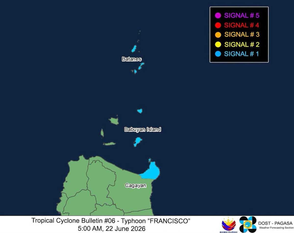
Typhoon Francisco further intensified today, June 22, with maximum sustained winds of 140 kilometers per hour near the center, which was 715 km east of Tuguegarao City, Cagayan as of 4 a.m., and gustiness of up to 170 kph.
Based on the Philippine Atmospheric, Geophysical and Astronomical Services Administration’s 5 a.m. advisory, Tropical Cyclone Wind Signal No. 1 was hoisted over Batanes, the northeastern portion of Cagayan (Gonzaga, Santa Ana) including the eastern portion of Babuyan Islands (Babuyan, Didicas and Camiguin islands).
PAGASA also warned of heavy rainfall and severe winds due to Francisco.
According to PAGASA, the southwest monsoon will bring strong to gale-force gusts over the following areas (especially in coastal and upland areas exposed to winds):
- Today: La Union, Pangasinan, Calabarzon, Romblon, Masbate, most of Visayas, Zamboanga peninsula, Misamis Occidental, Lanao del Norte, Camiguin, Surigao del Norte, Dinagat Islands, Davao Occidental, and Davao Oriental.
- Tomorrow, June 23: Most of Luzon, Visayas, Zamboanga peninsula, northern Mindanao, Surigao del Norte, Dinagat Islands, Davao Occidental, and Davao Oriental.
- Wednesday, June 24: Most of Luzon, Visayas, Dinagat Islands, Davao Occidental, and Davao Oriental.
“Francisco will further intensify and may reach its peak intensity by tomorrow. Thereafter, a weakening trend is expected,” PAGASA said. “It must be emphasized that heavy rainfall and severe winds may still be experienced in localities outside the forecast confidence cone.”
The state weather bureau noted Francisco will likely remain over the Philippine Sea throughout the forecast period. However, a closer approach to Extreme Northern Luzon is not ruled out should there be a westward shift in the forecast track.
“Francisco will move west northwestward until tomorrow (June 23). Afterwards, it will decelerate before recurving and exit the Philippine area of responsibility by Friday (June 26),” it said.
Considering these developments, PAGASA said public and disaster risk reduction and management offices concerned are advised to take all necessary measures to protect life and property.
“Persons living in areas identified to be highly or very highly susceptible to these hazards are advised to follow evacuation and other instructions from local officials,” it stressed.
From a tropical storm, Francisco developed into a typhoon on Sunday, June 21 and enhanced the southwest monsoon.
DepEd tells schools to be vigilant
The Department of Education (DepEd) instructed affected school division offices to remain vigilant.
On Sunday, the DepEd Disaster Risk Reduction and Management Service reminded the affected school division offices to “stay vigilant” and monitor the weather forecasts, and to promptly disseminate updated information to all learners and staff.
They should also maintain communication by making sure that all channels are operational, and to report incidents via the Incident Monitoring Reporting System.
It should also alert the School Disaster Risk Reduction and Management teams and activate the contingency plans as necessary, and to also preposition the emergency resources.
The school division offices should also protect the school assets by safeguarding the facilities, learning materials and equipment.
They should also coordinate their efforts with the local government units and disaster risk reduction and management councils to enhance emergency preparedness. – With Josiah Antonio, Evelyn Macairan


