



Tropical Storm Josie Enters PAR; Inday Death Toll Now 20
The state weather bureau said Tropical Storm Josie will bring strong to gale-force winds but “is less likely to directly affect the weather condition of the country throughout the forecast period.”
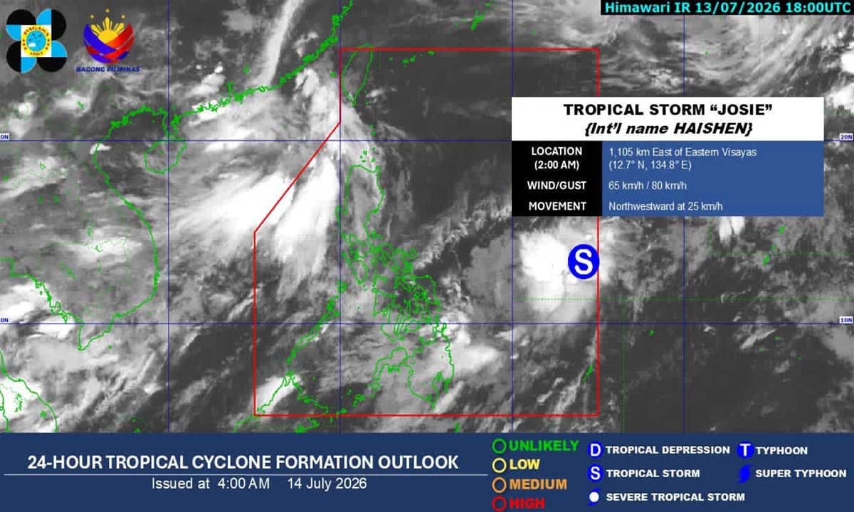
A tropical storm with the international name Haishen entered the Philippine area of responsibility as of 12:30 a.m. today, July 14, and was given the local name Josie, the Philippine Atmospheric, Geophysical and Astronomical Services Administration said.
In its 5 a.m. advisory, PAGASA said the center of Josie was at 1,085 kilometers east of eastern Visayas with a maximum sustained winds of 65 kilometers per hour near the center and gustiness of up to 80 kph.
According to PAGASA, Josie with bring strong to gale-force winds of up to 480 km from the center but “is less likely to directly affect the weather condition of the country throughout the forecast period.”
The southwest monsoon will bring strong to gale-force gusts over the following areas (especially in coastal and upland areas exposed to winds):
- Today: Ilocos region, Cordillera Administrative Region, Cagayan Valley, Central Luzon, Cavite, Batangas, and Occidental Mindoro
- Tomorrow, July 15: Ilocos region, Abra, Apayao, Zambales, Bataan, Batanes, and Babuyan Islands
- Thursday, July 17: Ilocos region, Abra, Apayao, Batanes, and Babuyan Islands
“It must be emphasized that heavy rainfall and severe winds may still be experienced in localities outside the forecast confidence cone,” PAGASA said.
Josie will move generally northward until tomorrow before turning northeastward throughout the remaining forecast period. It is forecast to exit PAR by tonight or tomorrow morning and steadily weaken into a tropical depression within the next 12 hours, PAGASA added.
Josie may further weaken into a low pressure area by tomorrow due to unfavorable environment.
“Considering these developments, the public and disaster risk reduction and management offices concerned are advised to take all necessary measures to protect life and property. Persons living in areas identified to be highly or very highly susceptible to these hazards are advised to follow evacuation and other instructions from local officials,” PAGASA said.
Meanwhile, state meteorologists noted that the southwest monsoon is now less likely to bring significant rainfall over the western sections of Northern and Central Luzon.
Cloudy skies with scattered rains and thunderstorms may occur in the Ilocos Region, Benguet, Zambales, Bataan and Tarlac.
Partly cloudy to cloudy skies with isolated rainshowers or thunderstorms may be experienced in Metro Manila and the rest of Luzon.
Inday death toll
The number of reported deaths from the combined effects of Typhoon Inday and the enhanced southwest monsoon has risen to 20, while 16 people are still missing, the Office of Civil Defense (OCD) said on Monday, July 13.
The reported fatalities subject to validation were from Tubungan, Iloilo, one; Malaybalay City and Quezon in Bukidnon, two; Jose Abad Santos, Davao Occidental, one; Malapatan, Sarangani, 10 and Calanogas, Lanao del Sur, six.
Nine people were reported injured while 16 people were reported missing. Around 654,000 people nationwide have been affected by the weather disturbances.
More than 20,100 people were in 162 evacuation centers, while 2,453 are being assisted outside evacuation centers.
Damage to infrastructure is estimated at P3.18 billion. The government has provided P43.38 million worth of assistance to affected communities.
Meanwhile, two men – Joel Ompoc, 24, and King Amir Montilla, 23, residents of Barangay Baclay in Tukuran and Barangay Dalapang in Labangan, respectively – are still missing after they were swept away by rampaging floodwaters in separate incidents at their barangays in Zamboanga del Sur on Saturday, July 11. – With Pia Lee-Brago, John Unson


