


Tropical Depression Luis To Bring Heavy Rains, Strong Winds; Signal No. 1 Up In Some Areas
Forecast rainfall may be higher in mountainous and elevated areas. Moreover, impacts in some areas may be worsened by significant antecedent rainfall, the state weather bureau said.
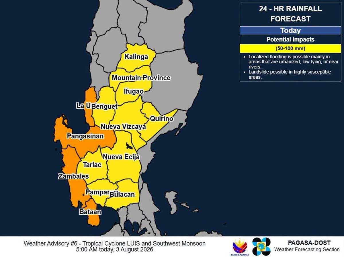
Tropical Depression Luis developed inside the Philippine area of responsibility (PAR) on Saturday, Aug. 1, and maintained its strength as of 4 a.m. today, Aug. 3, as it remains stationary over the sea east of Aurora, the Philippine Atmospheric, Geophysical and Astronomical Services Administration said.
According to PAGASA, the center of Luis was estimated at 130 kilometers eaast southeast of Casiguran, Aurora with maximum sustained winds of 55 km per hour near the center and gustiness of up to 70 kph
Tropical Cyclone Wind Signal No. 1 was hoisted over these areas in Luzon: the central and eastern portions of Cagayan (Enrile, Tuguegarao City, Peñablanca, Piat, Santo Niño, Camalaniugan, Tuao, Lal-Lo, Gonzaga, Alcala, Amulung, Santa Teresita, Baggao, Buguey, Solana, Rizal, Santa Ana, Gattaran, Iguig, Lasam, Aparri, Ballesteros, Abulug, Allacapan, Pamplona), Isabela, Quirino, the eastern and southern portions of Apayao (Flora, Santa Marcela, Conner, Pudtol, Luna), the eastern portion of Kalinga (City of Tabuk, Tanudan, Pinukpuk, Rizal), the eastern portion of Mountain Province (Paracelis, Natonin), the eastern portion of Ifugao (Aguinaldo, Alfonso Lista), the northern portion of Aurora (Dinalungan, Casiguran, Dilasag, Dipaculao, Baler), Polillo Islands, and the northern portion of Camarines Norte (Daet, Talisay, Paracale, Jose Panganiban, Capalonga, Vinzons).
Heavy rains and strong winds are expected due to Luis and the southwest monsoon.
PAGASA said Luis will move generally northwestward and may make landfall or pass close to Northern Luzon tonight or early morning tomorrow, Aug. 4. Afterwards, it will sharply turn east northeastward while moving away from the Philippine landmass. The forecast track is highly uncertain and may change in the succeeding bulletins.
“Luis is forecast to remain as a tropical depression over majority of the forecast period and may be downgraded into a remnant low by Wednesday (Aug. 5) before becoming fully assimilated into the circulation of Tropical Cyclone Dolphin,” PAGASA said.
Stranded passengers
As of Sunday afternoon, Aug. 2, the Philippine Coast Guard (PCG) had monitored 397 passengers stranded in five seaports because of Luis.
Data provided by the PCG said that as of 4 p.m. on Sunday, a total of 397 passengers, truck drivers and cargo helpers were stranded.
There were also 50 rolling cargoes and six vessels stranded in ports covered by the PCG districts in Southern Tagalog and Bicol.
PCG under alert
The PCG station in Northern Quezon also went on heightened alert due to Luis. It issued a Notice to Mariners, suspending sea travel for motorized boats and passenger vessels.
PCG Station Sorsogon also went on heightened alert and mobilized its Deployable Response Group units.
In a separate post, PCG Northern Cebu said it also activated its DRGs.
In its sea travel advisory, PCG District Bicol suspended the sea travel of all watercraft originating from, transiting through, or bound for Catanduanes and the eastern part of Camarines Norte.
The Coast Guard added that it is closely monitoring the movement of Luis and assured the public of its readiness to respond to the weather disturbance.
Class suspension
Meanwhile, several local government units in Bulacan have suspended classes due to the possible effects of Luis.
The cities of Malolos, San Jose del Monte and the town of Calumpit have announced class suspensions, according to Vinson Concepcion of the Philippine Information Agency in Bulacan.
Alternative delivery mode of learning will be implemented.
Manuel Lukban Jr., provincial disaster risk reduction management officer, said they are still collating the suspension of classes from other LGUs. – With Josiah Antonio, Evelyn Macairan, Ramon Efren Lazaro