



Super Typhoon Set To Enter PAR This Evening Or Tomorrow Morning
Super Typhoon Bavi, which will be called Inday locally, will maintain its strength as it enters the Philippine area of responsibility, the state weather bureau said.
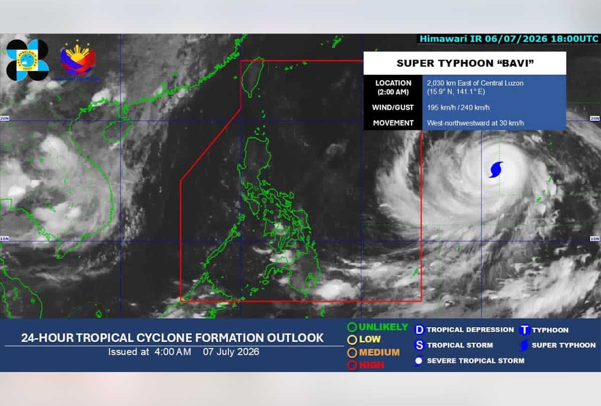
The super typhoon with international name Bavi will enter the Philippine Area of Responsibility (PAR) this evening, July 7, or early morning tomorrow, July 8, the Philippine Atmospheric, Geophysical and Astronomical Services Administration (PAGASA) said.
According to its 5 a.m. advisory today, Bavi has sustained winds of 195 kilometers per hour and gusts reaching up to 240 kph as of 3 a.m.
The super typhoon, which will be called Inday locally, will maintain its strength as it enters PAR, according to PAGASA.
State meteorologists spotted Bavi approximately 2,010 kilometers east of Central Luzon outside PAR as of this morning.
Although it is not expected to make landfall, Tropical Cyclone Wind Signal No. 2 and 3 may be raised over the northern and eastern portions of Northern Luzon as early as tonight or tomorrow morning.
Most parts of the country will experience gusty conditions between today and Wednesday, July 8, due to the southwest monsoon.
Heavy rains in the northern and western portions of the country will also be experienced due to the monsoon-enhanced weather conditions and the tropical cyclone.
Super Typhoon Inday is expected to exit PAR on Saturday, July 11, PAGASA said.
Preemptive actions
President Marcos has ordered the preemptive evacuation and preposition of relief goods and essential supplies in areas likely to be affected by the approaching super typhoon.
At a press briefing on Monday, July 6, Presidential Communications Undersecretary Claire Castro said the President has ordered a whole-of-government approach to minimize the impact of the weather disturbance.
Marcos has directed the National Disaster Risk Reduction and Management Council to conduct pre-disaster risk assessment scenario meetings and keep the NDRRMC and the Regional Disaster Risk Reduction and Management Council response clusters on standby, Castro said.
She said the President also instructed the NDRRMC to have the widest alert warnings and information campaigns across all channels and platforms.
Marcos likewise ordered concerned agencies to enforce sea travel bans, inspect critical infrastructure, provide early assistance to vulnerable sectors and monitor public health risks such as flood-related diseases.
High alert
Local government units in Metro Manila have gone on high alert.
San Juan City Mayor Francis Zamora – speaking in his capacity as president of the Metro Manila Council (MMC) – told radio dzMM that among the immediate directives issued to Metro Manila mayors is the mandatory prepositioning of disaster response equipment, rescue assets and relief food boxes to low-lying and flood-prone barangays.
Emergency personnel and operators of flood pumping stations across the metropolis have been placed on standby, with LGUs ensuring adequate fuel supplies to keep the flood control systems running continuously, he added.
To augment local resources, Zamora said the MMC is working in close coordination with the Department of Social Welfare and Development for the swift replenishment of relief food packs if necessary.
The mayor said on Sunday, July 5, that the Metro Manila Disaster Risk Reduction and Management Council will convene an emergency meeting today to fine-tune the region’s blueprint against the weather disturbance.
He said they will have a meeting with Metropolitan Manila Development Authority Chairman Don Artes this week “to ensure that all local governments are fully aligned and better prepared for Super Typhoon Inday.”
Zamora assured the public that standard disaster protocols have already been activated across Metro Manila’s 17 LGUs.
He added that he will also coordinate with the League of Cities of the Philippines to safely monitor preparations in areas outside Metro Manila that might be hit by the typhoon’s wide radius. — With Helen Flores, Rainier Allan Ronda


