


Francisco Intensifies Into Super Typhoon; Hailstorm Recorded In Provinces
The center of the eye of Super Typhoon Francisco as of 4 a.m. today, June 23, was estimated at 410 kilometers east of Aparri, Cagayan with maximum sustained winds of 185 kilometers per hour and gustiness of up to 230 kph.
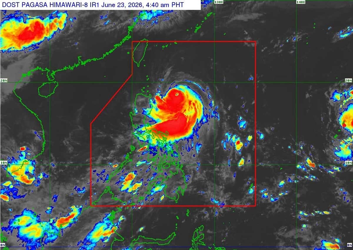
Francisco developed into a super typhoon as of 8 p.m. on Monday, June 22, maintaining its strength while slowing further over the sea east of Northern Luzon.
Based on the 5 a.m. advisory of the Philippine Atmospheric, Geophysical and Astronomical Services Administration (PAGASA) on Tuesday, June 23, the center of the eye of Francisco as of 4 a.m. was estimated at 410 kilometers east of Aparri, Cagayan with maximum sustained winds of 185 kilometers per hour and gustiness of up to 230 kph.
Tropical Cyclone Wind Signal No. 1 was raised over Batanes, the northeastern portion of Cagayan (Gonzaga, Santa Ana) including the eastern portion of Babuyan Islands (Babuyan, Didicas and Camiguin islands).
“Should there be a significant westward shift in the forecast track, Wind Signal No.2 may be hoisted in some localities of Babuyan Islands and Batanes. However, this scenario is becoming less likely as Francisco is now moving a more northwestward track,” PAGASA said.
The southwest monsoon and the periphery of Francisco will bring strong to gale-force gusts over the following areas (especially in coastal and upland areas exposed to winds):
- Today: Most of Luzon, Visayas, Zamboanga Peninsula, Northern Mindanao, Surigao del Norte, Dinagat Islands, Davao Occidental, and Davao Oriental.
- Tomorrow, June 24: Most of Luzon, Visayas, Misamis Occidental, Lanao del Norte, Camiguin, Dinagat Islands, Davao Occidental, and Davao Oriental.
- Thursday, June 25: Most of Luzon, Panay Island, Negros Occidental, and Northern Samar
“It must be emphasized that heavy rainfall and severe winds may still be experienced in localities outside the forecast confidence cone…This tropical cyclone will remain far from the Philippine landmass. Francisco is forecast to gradually decelerate while moving generally north northwestward until tomorrow morning before recurving towards the Ryukyu Islands in southern Japan. On the track forecast, Francisco will exit the Philippine area of responsibility (PAR) on Friday morning,” PAGASA reported.
The state weather bureau said Francisco may still further intensify or maintain its strength until this afternoon. Afterwards, a weakening trend is expected due to increasingly unfavorable environmental conditions.
The effects of the inclement weather were felt in parts of Metro Manila, where heavy rains and strong winds Sunday night caused three electric poles to collapse along a portion of M.H. Del Pilar Street in Barangay Maysilo, Malabon City.
According to the city government, one of the fallen poles struck a parked tricycle, while another smaller pole landed on the roof of a house.
No injuries were reported, but around 500 customers lost power due to the incident.
Manila Electric Co. vice president Joe Zaldarriaga assured affected residents that Meralco’s personnel were working to restore electricity service as soon as possible.
The affected stretch remained closed to traffic Monday morning as clearing and repair operations continued.
Motorists were advised to avoid the area and use alternate routes while the road remains closed.
Amid the threat of adverse weather conditions brought by Francisco and the enhanced southwest monsoon, government agencies have heightened their preparedness measures.
Philippine National Police chief Gen. Jose Melencio Nartatez Jr. said disaster response units had been activated to assist communities that may be affected by the typhoon and the enhanced southwest monsoon.
“Police units on the ground observe disaster response protocol and coordination with local authorities is included for a unified and quick action for the safety of the people,” he said.
“We advise the public to remain vigilant and follow orders from local authorities for their own safety,” Nartatez added.
The Philippine Coast Guard has also placed all operational units and its Deployable Response Group in the Northeastern Luzon District on heightened alert.
Meanwhile, a hailstorm occurred in Taal, Batangas and in Magalang, Pampanga on Sunday, June 21, according to PAGASA.
Weather specialist Charmagne Varilla told The Philippine STAR the hail event was recorded between 5 p.m. and 10 p.m. due to the severe thunderstorm.
Hail develops when strong thunderstorm winds carry raindrops high into freezing air, causing them to turn into ice.
While hailstorms are not a common weather phenomenon in the country, Varilla said the severe thunderstorm occurred because the atmosphere was moist.
“The environment is unstable, that’s why there is a formation of frequent thunderstorms, especially in the afternoon,” she told The STAR.
PAGASA issued a thunderstorm advisory on Sunday in Pampanga, Tarlac, Nueva Ecija and Metro Manila.
The state weather bureau also warned that moderate and heavy rains could occur in Tarlac, Zambales, Cavite, Batangas and Bulacan.
The uncommon occurrence coincided with the continued intensification of Typhoon Francisco over the Philippine Sea. — With Mark Ernest Villeza, Evelyn Macairan, Emmanuel Tupas


