


A Look Into Mindanao’s Earthquakes And Why They Happen
Last Wednesday’s magnitude 6.3 earthquake that shook Central Mindanao and neighboring provinces is just one of the hundreds of temblors that have rocked the island in the past decades.
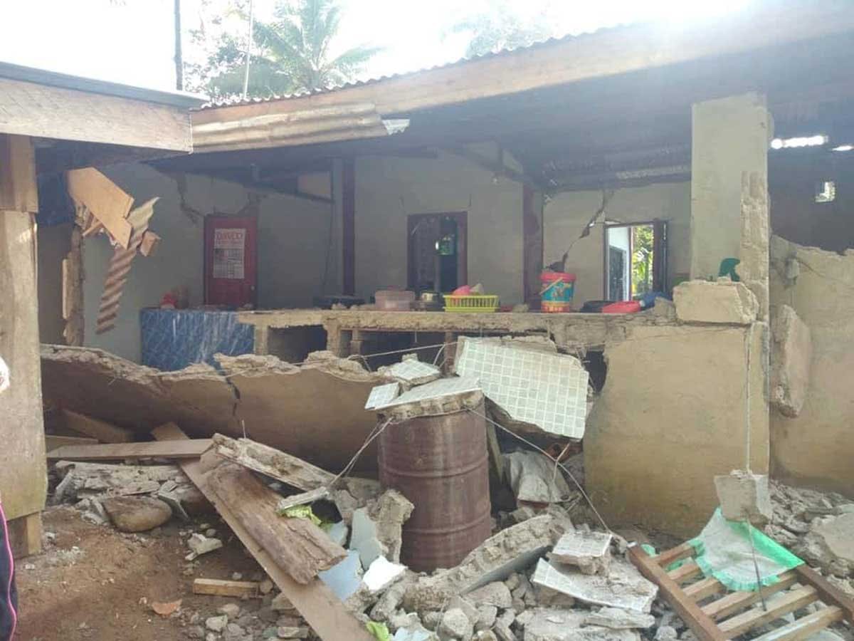
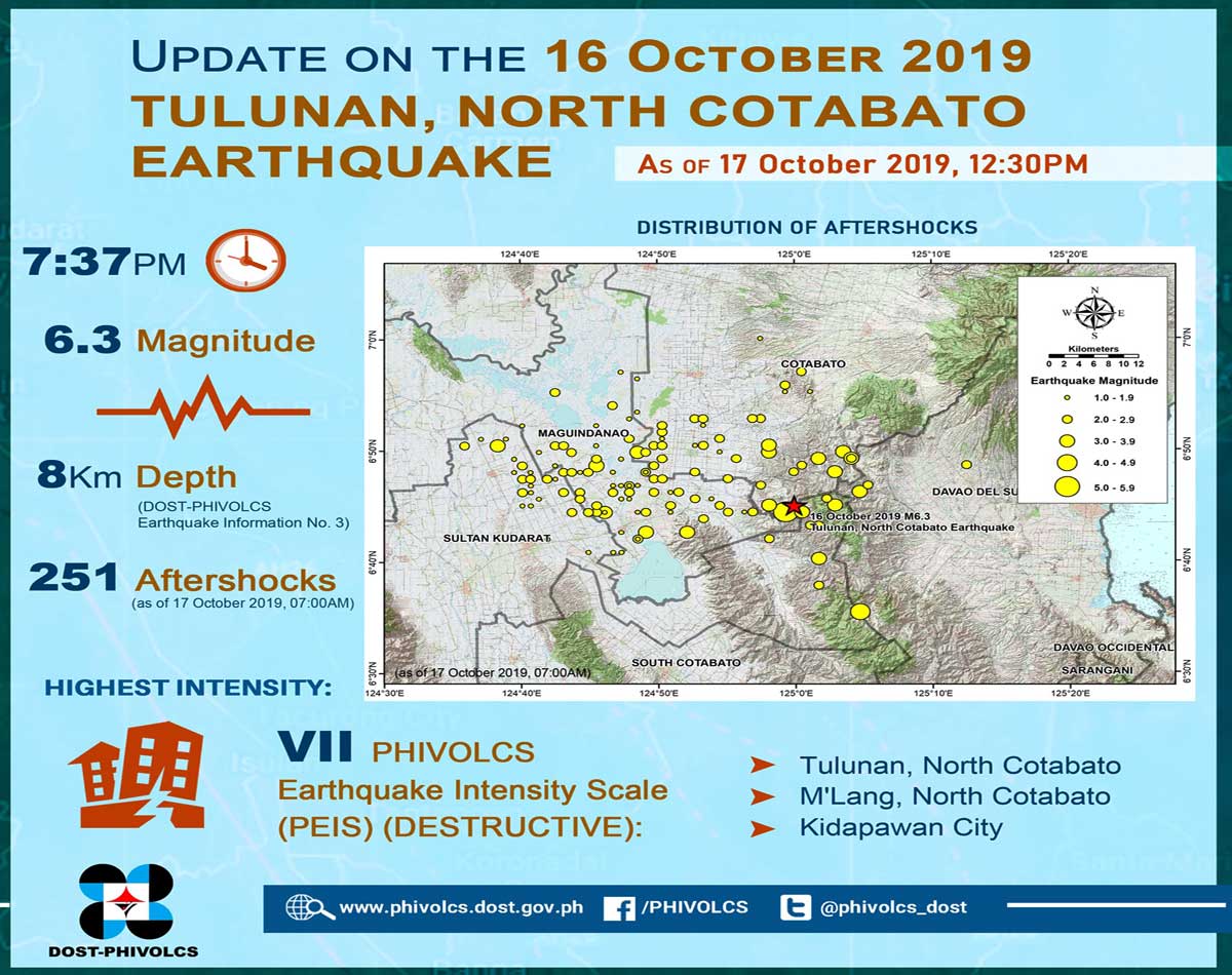
Another temblor rocked Central Mindanao on Wednesday night, Oct. 16. The magnitude 6.3 earthquake shook major cities such as Davao, Kidapawan and General Santos, causing damage to buildings and houses and leading people to scamper into open areas for safety.
According to the Philippine Institute of Volcanology and Seismology (Phivolcs), the epicenter of the earthquake, which was tectonic in origin, was detected in Tulunan, North Cotabato at a depth of eight kilometers. A tectonic earthquake occurs when the Earth’s crust breaks due to geological forces on rocks and adjoining plates that cause physical and chemical changes.
As of 7 a.m. yesterday, the agency had recorded 251 aftershocks in and around the epicenter, with some as strong as magnitude 5.3. According to the agency, the earthquake was felt as Intensity 7, which is destructive under the Phivolcs Earthquake Intensity Scale (PEIS), in Tulunan, as well as in Kidapawan and M’lang in North Cotabato.
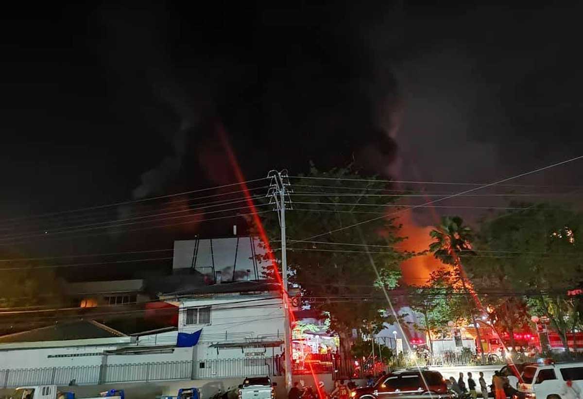
In General Santos, where the quake was felt at Intensity 4 (very strong), the temblor caused a fire at the Gaisano Mall that lasted for 18 hours before firefighters managed to put it out. In Digos City, Davao del Sur, the Cor Jesu College sustained substantial damage to its buildings, such as cracks and collapsed ceilings.
At least five individuals have been killed in the temblor, while over 60 others have been injured, according to the National Disaster Risk Reduction and Management Council (NDRRMC).
But compared to other recent earthquakes such as in Batanes and Pampanga, the NDRRMC said last Wednesday’s earthquake would have a lesser impact.
A constantly rocked island
Wednesday’s temblor is just one of several strong earthquakes that have hit Mindanao in the past 50 years.
According to the science website Earth Shaker, hundreds of earthquakes ranging from magnitude 5.1 to 7.1 have rocked the country’s second largest island from 1969 to 2019. The island’s proximity to major fault lines make it prone to earthquakes as well as volcanic activity.
“Historically, the most active earthquake generators in Mindanao are the Philippine Trench (located off the east coast of Mindanao), the segments of the Philippine Fault Zone (PFZ) that runs on the eastern portion of Mindanao, from Surigao to Davao Oriental, and Cotabato Trench on the southwestern coast of Mindanao island,” said Ralph Abainza, founder of Earth Shaker.
“It is important to note that there are also numerous active faults across Mindanao that generate earthquakes from time to time,” he added.

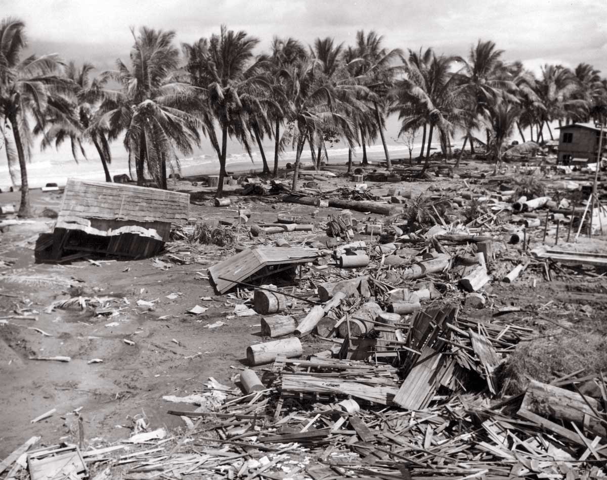
The Cotabato Trench alone, which stretches from Zamboanga del Sur up to the northern tip of Indonesia’s Sulawesi Island, has been the cause of several strong earthquakes in the region, including the 1976 Moro Gulf Earthquake, the deadliest earthquake in Philippine history.
When the magnitude 8 earthquake struck Mindanao on Aug. 17, 1976, it generated a nine-meter-high tsunami that destroyed several towns and cities along the 700-kilometer coastline around Moro Gulf.
“It was really deadly, causing more than 4,000 deaths. The earthquake occurred at 12:11 a.m., during which many were already resting in their homes. The strong quake at night caused power interruptions that made it hard for people to work on at night,” Abainza said of the earthquake.
According to the Phivolcs website, the deaths (85 percent), injuries (65 percent) and missing (95 percent) from the earthquake were due to the tsunami rather than the earthquake itself.
“A strong quake at midnight that was rapidly followed by a strong tsunami made it really deadly, plus, considering the reality that tsunami awareness was not as prevalent back then,” Abainza said.
The Cotabato Trench was also the cause of the magnitude 8.3 Celebes Sea earthquake, the strongest in Philippine history, which occurred on Aug. 15, 1918. It generated a 7.2-meter tsunami that devastated coastal communities along the Celebes Sea, from South Cotabato all the way to the BaSulTa (Basilan, Sulu and Tawi-Tawi) archipelago. The death toll was recorded at 52.
Following Wednesday night’s earthquake, people from coastal communities such as Davao City evacuated to higher ground over fears of a tsunami. Phivolcs director Renato Solidum allayed their fears and dismissed reports of tsunamis being generated by the quake as it happened inland.
However, earthquakes are not just tectonic in origin, as volcanic activity can also cause temblors.
“Quakes from volcanic activity can be considered equally dangerous with those of tectonic origin depending on the situation, such as its magnitude, proximity to populated areas or structures, and the preparedness of the community. Both types of quakes require precaution,” Abainza said.
He cited the eruption of the Hibok-Hibok Volcano on Camiguin Island in Northern Mindanao as an example. The volcano, which erupted from 1948 to 1951, was marked by several rumblings alongside eruptive activity. According to Abainza, these quakes led to landslides that aggravated the effects of the eruptions.
There are several active volcanoes in Mindanao, such as Musuan Peak in Bukidnon, Matutum in South Cotabato and Ragang in Lanao del Sur, which last erupted in 1867, 1911 and 1916, respectively.
According to Abainza, there is also a slim chance that dormant volcanoes such as Mount Apo, Mount Parker, Mount Leonard Kniaseff and Bud Dajo could return to activity like Mount Pinatubo, which erupted in 1991.


