


Maymay Intensifies Into Tropical Storm; Signal No. 2 Hoisted Over Areas In Luzon
According to the state weather bureau, Tropical Storm Maymay will move generally eastward and may make landfall over Ilocos Sur or La Union by this afternoon or evening.
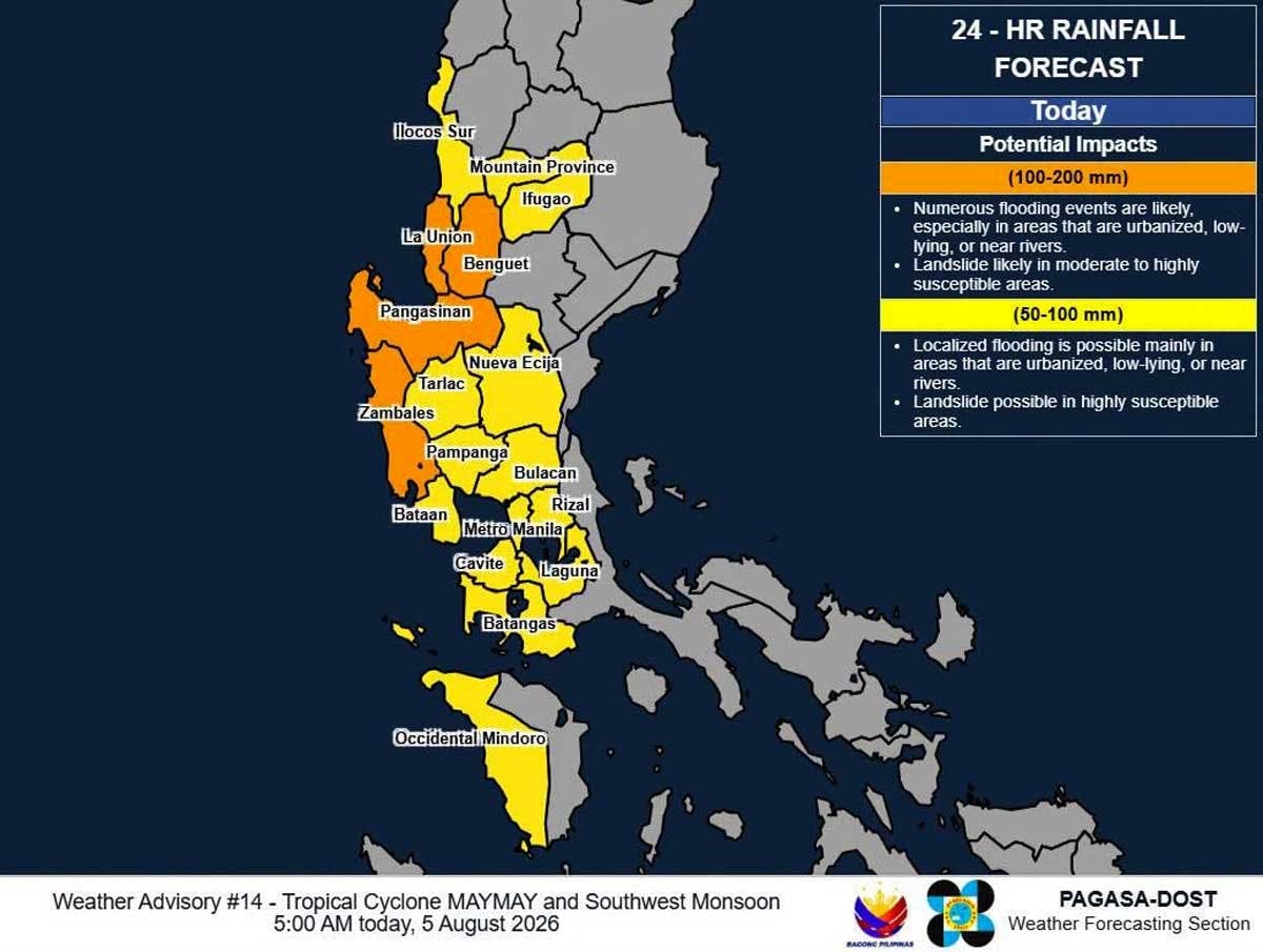
Tropical depression Maymay (Kujira) developed into a tropical storm as of 2:00 a.m. today, Aug. 5, while another typhoon with the international name Dolphin is being monitored outside the Philippine area of responsibility, the Philippine Atmospheric, Geophysical and Astronomical Services Administration (PAGASA) said.
In its 5 a.m. advisory today, PAGASA reported the center of Maymay was at 170 kilometers west northwest of Bacnotan, La Union and is expected to bring heavy rains and strong winds.
Tropical Cyclone Wind Signal No. 2 was hoisted over these areas in Luzon: central and southern portions of Ilocos Sur (Gregorio del Pilar, Magsingal, San Esteban, Banayoyo, Cervantes, Burgos, City of Candon, Santa Lucia, Santiago, San Vicente, Santa Catalina, Lidlidda, Nagbukel, Suyo, Sigay, San Ildefonso, Galimuyod, Quirino, City of Vigan, San Emilio, Caoayan, Alilem, San Juan, Santa, Bantay, Santo Domingo, Sugpon, Tagudin, Santa Cruz, Santa Maria, Narvacan, Salcedo), the northern and central portions of La Union (Luna, Caba, Santol, Bauang, City of San Fernando, San Juan, Bagulin, Aringay, Bangar, San Gabriel, Burgos, Naguilian, Bacnotan, Sudipen, Balaoan), the northwestern portion of Pangasinan (Anda, Bolinao, Bani), the southwestern portion of Abra (Manabo, Pidigan, Langiden, Luba, Boliney, Sallapadan, Bucloc, Tubo, Villaviciosa, Pilar, Peñarrubia, San Isidro, San Quintin, Bangued, Bucay), the western portion of Mountain Province (Besao, Tadian), and the northwestern portion of Benguet (Mankayan, Kapangan, Kibungan, Sablan, Bakun).
Under Signal No. 1 in Luzon are: Ilocos Norte, the rest of Ilocos Sur, the rest of La Union, the rest of Pangasinan, Apayao, the rest of Abra, Kalinga, the rest of Mountain Province, Ifugao, the rest of Benguet, Cagayan, Isabela, Quirino, Nueva Vizcaya, the northern portion of Zambales (Candelaria, Santa Cruz, Masinloc, Palauig), the northern portion of Tarlac (Mayantoc, San Clemente, Camiling, Santa Ignacia, Gerona, Paniqui, Moncada, San Manuel, Anao, Ramos, Pura), the northern portion of Nueva Ecija (Carranglan, Lupao, Cuyapo, Talugtug, Nampicuan, Guimba, Science City of Muñoz, San Jose City, Pantabangan), and the northern portion of Aurora (Dilasag, Casiguran, Dinalungan, Dipaculao).
“Maymay will move generally eastward and may make landfall over Ilocos Sur or La Union by this afternoon or evening. Afterwards, it will traverse the landmass of Northern and Central Luzon until tomorrow (Aug. 6),” PAGASA said.
“Maymay is forecast remain as a tropical storm as it approaches the Philippine landmass. After making landfall, Maymay will weaken into a tropical depression by tomorrow morning and may be downgraded further into a low pressure area by tomorrow afternoon or evening,” PAGASA added.
PAGASA is also monitoring Dolphin outside PAR as the southwest monsoon, enhanced by a low-pressure area (LPA), continues to bring heavy rains across the country.
Tropical Depression Luis, meanwhile, dissipated on Tuesday, Aug. 4, after being downgraded.
At around 5:30 p.m. Monday, Aug. 3, Luis made its first landfall over Maconacon, Isabela before weakening into an LPA at around 8 p.m. It had an unlikely chance of reforming into a tropical cyclone before it was reported to have dissipated at around 4 p.m. on Monday.
As Luis weakened, another LPA, which is now Tropical Storm Maymay, formed near it. Based on the latest weather satellite image, it was last located 180 kilometers west of Bacnotan, La Union.
Road restrictions
The persistent rains from the different weather systems have affected major transportation routes in Northern Luzon.
In Baguio City and Benguet, torrential rains spawned by the enhanced southwest monsoon triggered landslides and rockfalls that disrupted travel across the Cordillera on Monday.
The most serious disruption was reported along Marcos Highway in Sitio Caucalan, Barangay Taloy Sur in Tuba, Benguet, where a landslide buried part of the highway, forcing authorities to reduce traffic to one lane.
As of Monday, only the northbound lane toward Baguio City remains open, while the southbound lane heading to La Union has been temporarily closed to allow debris clearing and ensure motorists’ safety.
Intermittent rockfalls, soil erosion and overflowing drainage were also reported amid persistent rains along Kennon Road and Naguilian Road.
Motorists traveling along Halsema Highway were likewise advised on Monday to remain alert as saturated slopes increased the risk of landslides.
The Department of Public Works and Highways, police and local disaster officials urged motorists to avoid unnecessary travel, slow down when passing landslide-prone areas and strictly follow traffic advisories.
The rains also slightly raised the water level of Angat Dam, although it remained below its critical elevation.
Records from the Bulacan Provincial Disaster Risk Reduction and Management Office showed that the water elevation of Angat Dam as of 2 p.m. on Monday reached 156.71 meters from 155.75 meters the previous day, an increase of 0.96 meter.
However, the level remained 3.29 meters below its critical elevation of 160 meters, 23.29 meters below its normal operating level of 180 meters and 55.29 meters below its rainy season normal high water level of 212 meters.
Flight disruptions
The Civil Aviation Authority of the Philippines, meanwhile, reported flight disruptions due to unfavorable weather conditions.
Cebu Pacific canceled Flight 5J 506 (Manila-Tuguegarao) and Flight 5J 507 (Tuguegarao-Manila).
Three other flights were diverted to Clark International Airport: Cebu Pacific Flight CEB860 (Zamboanga-Manila), which landed at 1:19 p.m.; GAP2814 (Davao-Manila), which landed at 1:23 p.m. and Cebu Pacific Flight CEB280 (Denpasar, Bali-Manila), which landed at 1:30 p.m. – With Artemio Dumlao, Ramon Efren Lazaro, Rudy Santos, Cesar Ramirez, Jun Elias