


Karding Now A Super Typhoon; Storm Surge Warning Up
The state weather bureau warned of possible storm surges, typhoon-force winds and torrential rains after Karding intensified into a super typhoon ahead of its expected landfall on Sunday night.
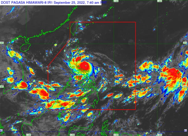
UPDATED (8 a.m.) – In a span of 24 hours, tropical cyclone Karding rapidly intensified from a severe tropical storm into a super typhoon as it barrels toward Luzon, where it is expected to make landfall on Sunday, Sept. 25.
The Philippine Atmospheric, Geophysical and Astronomical Services Administration (PAGASA) warned of “typhoon-force” winds and “heavy to intense with at times torrential rains” in areas on the path of super typhoon.
“There is a high to very high risk of storm surge in the low-lying and exposed coastal areas of northern Quezon including Polillo Islands and the central and southern portions of Aurora,” the state weather bureau said in its bulletin issued at 8 a.m. Sunday.
“In addition, a moderate to high risk of storm surge is also possible over Camarines Norte, Pangasinan, Zambales, Bulacan, the northern portion of Metro Manila, the southern portion of La Union, and the rest of Aurora and Quezon,” it added.
PAGASA said the combined effects of storm surge and high waves breaking along the coast may cause life-threatening and damaging inundation or flooding.
Karding was monitored 230 kilometers east of Infanta, Quezon as of 7 a.m. Sunday. It is moving west southwestward at a speed of 20 km per hour and was carrying maximum sustained winds of 185 kph near the center and gustiness of up to 230 kph.
According to the weather bureau, Karding reached the highest tropical cyclone classification following a period of explosive intensification of 90 kph in 24 hours.
The super typhoon is expected to make landfall in the vicinity of northern Quezon or southern Aurora on Sunday night, although the possibility of an afternoon landfall in Polillo Islands was not ruled out.
PAGASA said tropical cyclone wind signal No. 5 will be hoisted in areas that will be directly on track of Karding.
It raised signal No. 4 over Polillo Islands and signal No. 3 over Bulacan, the eastern portion of Pampanga, the central and southern portions of Aurora and Nueva Ecija, the northeastern portion of Laguna, and the northern portions of Metro Manila, Rizal, Quezon and Camarines Norte.
Meanwhile, signal No. 2 has been hoisted over Quirino, Nueva Vizcaya, Benguet, La Union, Pangasinan, Zambales, Bataan, Tarlac, Cavite, Batangas, Catanduanes, the southern portion of Isabela, the northern portion of Camarines Sur, and the rest of Pampanga, Nueva Ecija, Aurora, Metro Manila, Laguna, Rizal and Camarines Norte.
Signal No. 1 was hoisted over Kalinga, Abra, Mountain Province, Ifugao, Ilocos Sur, Marinduque Albay, Sorsogon, Burias Island and Ticao Island, the southern portions of Cagayan and Ilocos Norte, the northern portions of Oriental Mindoro and Occidental Mindoro including Lubang Islands, and the rest of Quezon and Camarines Sur.
Moderate to heavy rains are expected over Isabela, Polillo Islands, Catanduanes, Camarines Norte, Camarines Sur and Isabela throughout Sunday morning until afternoon.
Heavy to intense with at times torrential rains will be experienced in Metro Manila, Zambales, Bataan, Tarlac, Pampanga, Nueva Ecija, Bulacan, Aurora, Rizal and the northern portion of Quezon including Polillo Islands from early Sunday afternoon to early morning on Monday, Sept. 26.
Moderate to heavy with at times intense rains were forecast over Isabela, Nueva Vizcaya, Quirino, Benguet, Ifugao, Mountain Province, Pangasinan, Cavite, Laguna, the central portion of Quezon and Camarines Norte during the same period.
“Under these conditions, scattered to widespread flooding and rain-induced landslides are expected, especially in areas that are highly or very highly susceptible to these hazard as identified in hazard maps and in localities with significant antecedent rainfall,” said PAGASA.
It is also expected to enhance the southwest monsoon and bring possible occasional monsoon rains over Visayas and the rest of Southern Luzon, especially on their western sections.
After making landfall, Karding is expected to traverse the landmass of Central Luzon and emerge over the West Philippine Sea via the coastal waters of Zambales or Pangasinan.
“The typhoon will then continue tracking generally westward over the West Philippine Sea for the remainder of the forecast period,” said PAGASA.
“It is forecast to continue intensifying and may make landfall at or near a peak intensity of 185-205 km/h. Frictional effects during landfall and traverse of the Luzon landmass will weaken Karding throughout the evening (Sunday) through tomorrow early morning (Monday), although it is highly likely that this tropical cyclone will remain a typhoon while crossing the landmass,” it added.
PAGASA advised the public and disaster risk reduction and management offices to take all necessary measures to protect life and property.
“Persons living in areas identified to be highly or very highly susceptible to these hazards are advised to follow evacuation and other instructions from local officials,” it added.


