


Signal No. 2 Up Due To Kabayan
The Philippine Atmospheric, Geophysical and Astronomical Services Administration called on the residents affected by Tropical Storm Kabayan to prepare, particularly those with warning signals.
The low pressure area spotted east of Surigao del Sur has developed into Tropical Storm Kabayan, the 11th cyclone to enter the country this year, according to state weather bureau Philippine Atmospheric, Geophysical and Astronomical Services Administration (PAGASA).
Kabayan (international name Jelawat) was expected to make landfall either in Davao Oriental or Surigao del Sur, which was recently hit by a magnitude 7.4 earthquake, PAGASA assistant weather services chief Chris Perez said at a press conference.
“The center of Tropical Storm Kabayan was estimated based on all available data over the coastal waters of Caraga, Davao Oriental,” PAGASA said on Monday, Dec. 18, in its latest weather bulletin posted on Facebook at 5 a.m.
At 4 a.m., PAGASA reported that Kabayan had maximum sustained winds of 65 kilometers per hour near the center and gustiness of up to 80 km/h.
Perez said those affected by Kabayan should prepare, particularly those with warning signals.
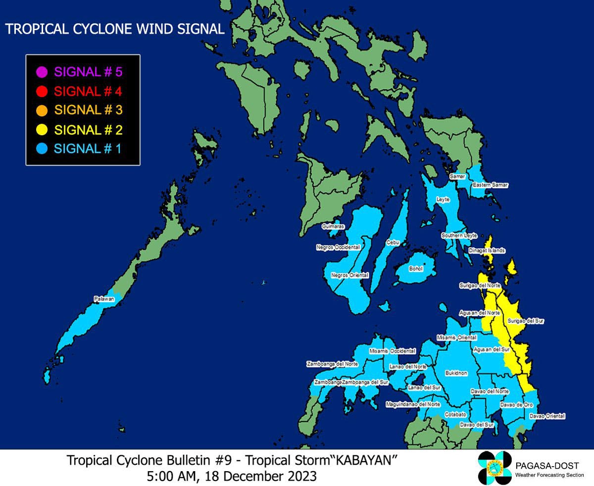
In Mindanao, Tropical Cyclone Wind Signal No. 2 was raised in Dinagat Islands, Surigao del Norte including Siargao and Bucas Grande Islands, Surigao del Sur, the northern portion of Agusan del Norte (Kitcharao, Jabonga, Santiago, City of Cabadbaran, Remedios T. Romualdez, Tubay), the eastern portion of Agusan del Sur (Trento, Bunawan, San Francisco, Rosario, Prosperidad, City of Bayugan, Sibagat), and the northern portion of Davao Oriental (Boston, Cateel).
Signal No. 1 was raised in 𝐋𝐮𝐳𝐨𝐧: southern portion of mainland Palawan (Sofronio Española, Brooke's Point, Bataraza, Balabac, Rizal, Quezon, Narra) and Cagayancillo Islands
𝐕𝐢𝐬𝐚𝐲𝐚𝐬:
Southern Leyte, Leyte, the southern portion of Samar (Basey, Santa Rita, Marabut, Talalora, Villareal, Pinabacdao), the southern portion of Eastern Samar (Maydolong, City of Borongan, Quinapondan, Guiuan, Lawaan, Balangiga, Llorente, Giporlos, Salcedo, Balangkayan, General Macarthur, Hernani, Mercedes), Cebu including Camotes and Bantayan Islands, Bohol, Siquijor, Negros Oriental, Negros Occidental, and Guimaras
𝐌𝐢𝐧𝐝𝐚𝐧𝐚𝐨:
The rest of Agusan del Norte, the rest of Agusan del Sur, the central portion of Davao Oriental (Baganga, Manay, Caraga, Tarragona, Lupon, Banaybanay), Davao de Oro, Davao del Norte, Davao City, Camiguin, Misamis Oriental, Bukidnon, Misamis Occidental, Lanao del Norte, Lanao del Sur, the northern portion of Maguindanao del Norte (Buldon, Barira, Matanog, Parang, Sultan Kudarat, Sultan Mastura), the northern portion of Cotabato (Arakan, Carmen, Banisilan, Alamada, President Roxas, Kabacan, Matalam, Antipas, Magpet, Libungan, Pigkawayan), the northern and central portions of Zamboanga del Norte (Siayan, Sindangan, Jose Dalman, Manukan, Pres. Manuel A. Roxas, Sergio Osmeña Sr., Katipunan, Dipolog City, Polanco, Mutia, Piñan, Dapitan City, Sibutad, La Libertad, Rizal, Siocon, Baliguian, Gutalac, Labason, Kalawit, Tampilisan, Liloy, Salug, Godod, Bacungan), Zamboanga del Sur, Zamboanga Sibugay.
On the track forecast, PAGASA said Kabayan will likely to make landfall as a tropical storm along the coast of Davao Oriental or southern Surigao del Sur this morning, Dec. 18.
“It will then cross the rugged terrain of Mindanao, and emerge over the Sulu Sea between this afternoon and evening. Due to frictional effects associated with landfall, Kabayan is forecast to be downgraded into a tropical depression, and the possibility of being further downgraded into a low pressure area while over land or after emerging over the sea is not ruled out (although in such a case, re-development may still occur over the Sulu Sea),” PAGASA added.
PAGASA said Kabayan will move across the Sulu Sea south of Cagayancillo Islands and then make another landfall over central or southern Palawan as a tropical depression by Tuesday morning or afternoon, Dec. 19, then emerge over the West Philippine Sea.
At least 100 to 200 millimeters of rainfall are expected in Surigao del Sur, Surigao del Norte, Dinagat Island and Southern Leyte while at least 50 to 100 millimeters of rain will affect Eastern Visayas, Davao region, Northern Mindanao and the rest of Caraga region.
“Flooding and rain-induced landslides are likely especially in areas that are highly susceptible and experienced considerable amounts of rainfall for the past several days,” he said.
Perez added that aside from Kabayan, the shear line will also bring rain to the Southern Luzon area.
PAGASA administrator Nathaniel Servando said that areas affected by the recent magnitude 7.4 quake in Mindanao should take necessary precautions.
?
Angat Dam
PAGASA said on Sunday they have begun releasing Angat Dam water in anticipation of rainfall from Kabayan and the southeast monsoon.
At a press conference, PAGASA hydro specialist Richard Orendain defended their decision to open Angat Dam’s gates amid the Metropolitan Waterworks and Sewerage System (MWSS)’s request to allow the dam’s elevation to reach 214 meters before spill gates are opened.?
“The request of MWSS of 214 meters water elevation is possible but the problem here is that based on our protocol, if it reaches 212 (meters) and there is an increase in the inflow, we need to release water to prevent the bigger problem of possible collapse of the dam,” Orendain said.
He added that at least three spill gates were discharging water as of 12 p.m. on Sunday.?
“We cannot delay the release amid the volume of the water inflow as strong rains are being experienced in the watershed and aside from this, we also have the typhoon which is expected to enhance rains within the watershed of Angat dam,” he said.
Before the release of Angat Dam water, Orendain said local government units were already informed.?
“A day before the release of water from the dam, we released an advisory at 10 a.m. on Dec. 15 and informed the local governments of Bulacan, the provincial governor plus the municipal governments particularly Norzagaray, Bustos, San Rafael, Baliuag, San Rafael, Pulilan, Calumpit, Hagonoy and Paumbong,” he said.
PAGASA Climate Monitoring and Predictions section chief Ana Solis maintained that consultation was made before the release of water.?
“Last Dec. 7 as part of the technical working group, the MWSS, the National Power Corporation and the National Water Resources Board, we also gave the same reason that we cannot wait for up to 214 water level as we need to protect the integrity of Angat Dam, so we conducted a consultation on this,” Solis said.
PCG stations
Four Philippine Coast Guard (PCG) stations under the Central Visayas District (CVD) temporarily suspended the sea travel of all vessels on Sunday after their areas of responsibility were placed under signal 1 due to Kabayan.
PCG-CVD posted on Facebook that Notices to Mariners were issued after the state weather bureau released its Tropical Cyclone Bulletin No. 2.
“Coast Guard Station Western Bohol is now enforcing ‘temporary suspension’ of voyages for all types of vessels/watercraft as proactive measures to avert maritime accidents and relative to prevailing weather and sea conditions in the area of responsibility,” said PCG Station Western Bohol commander Lt. Wenceslao John Wenceslao.
Acting PCG Station Central Cebu commander Mark Larsen Mariano said they would allow vessels to resume operation once the weather and sea conditions improve.?
Two other PCG stations that issued a notice were Camotes Island through Ensign Reynann Lagare Jr. and Eastern Bohol through Ensign Dexter Carandang. – With Evelyn Macairan


